
Mars Global Surveyor Magnetic Field Experiment
Martian Magnetic Map
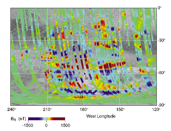
This image is a close-up from a map of Martian magnetic fields, created using the magnetometer/electron reflectometer instrument on board NASA's Mars Global Surveyor spacecraft. The false blue and red colors represent invisible magnetic fields in the Martian crust that point in opposite directions. The magnetic fields appear to be organized in bands, with adjacent bands pointing in opposite directions, giving these stripes a striking similarity to patterns seen in the Earth's crust at the mid-oceanic ridges. On the Earth, the sea floor slowly spreads apart as new crust is extruded from Earth's hot interior, with the resulting stripes carrying a frozen record of the past few hundred million years of Earth's magnetic history.
This area on Mars is in the southern highlands near the Terra Cimmeria and Terra Sirenum regions, centered around 180 degrees longitude from the equator to the pole. It is where magnetic stripes possibly resulting from crustal movement are most prominent. The bands are oriented approximately east - west and are about 100 miles wide and 600 miles long, although the longest band stretches more than 1200 miles.
IMAGE CREDIT: NASA, Jack Connerney, Mario Acuña, Carol Ladd
- NASA Official: Ron Oliversen
- Email: Ronald.J.Oliversen@nasa.gov
- Curator: Patricia Lawton, ADNET Systems, Inc.
- Email: Patricia.J.Lawton@nasa.gov
- Last Modified: 17 January 2017